ArkHaven

Community of Christ Church

Prophetic History Of Ozark Mountains being a safe place…

THE NAVY AND NASA HAVE ESTABLISHED THAT IN EVERY PHYSICAL SENSE.
THE OZARK PLATEAU IS THE SAFEST PLACE ON EARTH.

Ozark Community

The Ozarks (also referred to as Ozarks Mountain Country, and the Ozark Plateau) are a physiographic and geologic highland region of the central United States. It covers much of the southern half of Missouri and an extensive portion of northwestern and north central Arkansas. The region also extends westward into northeastern Oklahoma and extreme southeastern Kansas.

Safe Christian Sanctuary

Prophetic History Of Ozark Mountains
being a safe place

I felt inspired to write this prophetic overview of all the Lord has shown me since 1972 as a lead-in to this article on the Ozarks as a safe haven in these prophetic end-times. I think you will find it an important read.

THE NAVY AND NASA HAVE ESTABLISHED THAT IN EVERY PHYSICAL SENSE THE OZARK PLATEAU IS THE SAFEST PLACE ON EARTH

AND MORE IMPORTANTLY, THE HOLY SPIRIT HAS CONFIRMED TO SOME THAT MUCH OF THE OZARKS MAY BE SPIRITUALLY AND DIVINELY PROTECTED

Prophetic History Of Ozark Mountains being a safe place

  • In 1983 the Lord told me (in a soy bean field in Illinois where I went to pray) to move here, and in 1984 when I drove into this area for the first time He told me I was entering into “A Green Island of Survival.” I met the ghost writer for one of Corrie ten Booms books in Green Forest (Cliff Dudley, founder of New Leaf Publishing, now deceased), and he told me about her vision experience she had while touring the Passion Play grounds. When she saw angles on the full circumference of the horizon, all the way around. in ranks five deep (i.e., rows front to back. This would match how Israel went into battle), swords drawn, she exclaimed, “My, my…. this is a divinely protected place.”  I have never been able to confirm that experience.  And here is another popular story that can not be confirmed.

  • There used to be a little newspaper put out, called “The Corner Gathering” that was made up of the testimonies of others who knew God sent them here.  One of those stories attributed to Bill Gothard [founder of the Quiverfull cult] purports that Corrie had a vision when a passenger in his airplane. According to the story she noticed a ring of fire down below and exclaimed that this must be a divinely protected area.  The pilot purportedly said… they were flying over the north west corner of Arkansas at that moment.

  • But Bill Gathard will only say this about that report. “Corrie Ten boom often stayed at our headquarters’ campus. She had a special room that she decorated. However, she never flew with me to seminars. She did tell me about her impressions while flying over Arkansas.” Unfortunately Gathard did not share what those impressions were.

  • I know the author of The Corner Gathering and have met a number of the people whom she quoted, and I have had many other confirmations….

  •  Matthew 24:8, a eschatological passage, says “But all these things are merely the beginning of birth pangs.”  Birth pangs have to do with upheavals of the planet itself as it goes through changes caused by celestial events.  It would seem that this passage says volcanoes and earth quakes (this sort of thing) will happen on an unprecedented level.  Because of the physical makeup of the Ozark Plateau, and because the Lord’s covering over this area I am assuming that covering includes birth pangs as well.

    • That is why I am here, and that is why so many people come to let me show them this divinely protected island of survival.  As a caution or disclaimer it needs to be pointed out that there are many Bible passages that speak of divine covering.  But we have to understand them in context.  That does not mean no harm will come to any area within the Ozarks in Arkansas or Missouri.  Relatively speaking there will be less harm in a major part of the Ozarks. 

    Even though the Boston mountain range in the Ozarks is perhaps the safest place on earth, I am sure that any area within the Ozarks that is mountainous and remote is probably just as safe.  Preppers always warn us to stay away from flat areas (tornado and flood prone) and towns of any size.

    To me the most important point we can make here is to know where God is sending you and then be obedient and move there.  But confirm that first by making visits to that area to see if He confirms that in your spirit.  If you feel attracted to more that one area, visit them all and see which one God confirms for you.  As I say –probably too often– the safest place on earth is in the center of God’s will for you.  See my testimony on how the Lord confirmed this area to me.

  •  “If I am to live by my faith, I must do as Noah did and build an ark to ride out the storm.

       “By faith Noah . . . moved with fear, prepared an ark to the saving of his house” (Hebrews 11:7)

        The ark that Noah built represents Jesus Christ — and there is no other safe place on earth.” (Quoted from David Wilkerson)

  • The Ozarks are called a mountain range, but keep in mind that the average elevation is from 1,000 to 2,000 feet above sea level.  The biggest mountain in the Ozarks wouldn’t make an noticeable bump in the Rocky Mountains or the Alps.  But the Ozarks have huge advantages over those grand mountain ranges.  Being in the south there is very little snow and it usually melts the next day.  There are no noticeable earth quakes, never any hurricanes, no forest fires, no flooding except in low areas, long growing season, and lots of rain.  Tornadoes are rare in the mountainous areas. I grew up in Colorado and visited the Rockies a lot, but I would pick the Ozarks over the Rockies any day as the ideal place to live.

  • Go to this website to see dozens of pictures of the beautiful Ozarks besides these.

  • Other maps below show location of towns
    The Ozarks have lakes, rivers, creeks and springs and lots of rain!
    Beaver Lake
    There hasn't been a forest fire in the 30 years I have lived here
    Famous Bass tournaments held at several huge lakes
    A fawn in the woods
  • Look at this map of the USA again and notice the orange spot that signifies the Ozarks.

  • Then notice how far away the gulf coast and pacific and atlantic costs and the Canadian boarder are.  They are hundreds of miles away, isolating the Ozarks from any purported invasion of any sort that some predict.  This gives the Ozarks a huge advantage over all the other safe areas… in my estimation.  (The orange spots on the map show three different plateaus in the USA.)

  • If you feel led to move to the Ozarks (or anyplace else), be sure you know the specific area God is calling you to, and the specific people you are to go into community with.  There are several kinds of communities, but whichever one you feel led to, be sure you are also led to the people.
  • May the Lord open your eyes to see His safe place for you. “Then Elisha prayed and said, “O LORD, I pray, open his eyes that he may see ” And the LORD opened the servant’s eyes and he saw; and behold, the mountain was full of horses and chariots of fire all around Elisha.”  ~2 Kings 6:17

  • Safe Christian Sanctuary
    • One more point that rounds out this testimony. In 1974 the Lord told me that my life’s commission was to prepare His people for a coming total crash of the economy and society.  No one believed me in 74, 84, or 94.  Just a few did in 2004, but now they do … in large numbers.

    • All of these testimonials were greatly abbreviated so as to make the poignant point. If you want to read the full version, see it here.  We are very blessed to be in a divinely protected place that was prepared for such a time as this.  Of course there are other safe places around the world. I am just saying that this is the one I was sent to and was give all this confirmation for.

  • In 1986 while living on a blueberry farm, the Lord gave me the name and logo for my ministry. ArkHaven (in reference to Noah’s Ark and the Ark of the covenant) is God’s place of provision, protection, and promise.
  • In 1999 the Holy Spirit told me that Y2K was going to be a non-event,
    but it would blind or inoculate people from the REAL event to prepare for. 
  • In eschatological terms, the times leading into the Tribulation period (from 1948 when Israel became a nation until the first day of the Tribulation period).  The time is short to adequately prepare for that day, physically, mentally, and especially spiritually. By preparation I refer to a self sufficient community of like minded Christians adopting an agrarian lifestyle that has proven itself to work the best of all lifestyles over the past 6,000 years. And since I am an Acts model (the whole book) Christian, I wish to go into community with other Acts model Christians.
  • As the old Hebrew saying goes, “I would rather be one year too early than 10 minutes too late” in moving where God told me to go

  • Divinely Protected "Safe" Areas Shown in:

    Portions of Maine, Vermont, and Quebec

    Portions of West Virginia, Kentucky, & Tennessee

    Portions of Missouri & Arkansas

    Note the disclaimer found at this link

    Statistically, nearly three quarters of Americans move every five years … so chances are pretty good that you could be relocating again. Obviously, moves are often driven by major life transitions, like a new job, a marriage, or retirement. And sometimes you don’t really have much of a choice in your destination.

    But quite often, you do have a choice. And that’s important, because …

    One of the very best things you can do to live and survive hard times is to move where the likelihood of major events affecting you is minimized.

    There are plenty of places like that in the United States … as long as you think critically and evaluate your options using the right criteria.

    The above map shows the purported location of three of the five divinely protected areas in the USA, North West Arkansas being one of them.  The next map shows the other two areas.

    Here is the story behind this map:  A friend of mine gave me a copy of this map around 1990.  A friend of his says five prophetic men (who did not know each other and had never met) where directed by the Holy Spirit to meet with each other at a hotel in Chicago.  After they arrived and discerned who the others were, they rented a room and began to discuss the things the Holy Spirit had directed them to share with each other. 

    One of the things they purportedly discussed was divinely protected areas where Christians would go to not just survive when national disaster struck, but to save a lot of lives and to minister Christ to the refugees that would gather there at that time. 

    They turned to the page on an Atlas map that shows the continental United States and each in turn drew a circle around an area the Holy Spirit had shown them to be a protected area. 

    The map is like prophecy and needs to be judged as such.  In fact, it was generated by purportedly prophetic brothers at the meeting in Chicago.  Even if I had the source, it would make no difference.  It’s either supported by the Holy Spirit, or it isn’t. 

    Keep in mind that this does not mean there are not more divinely protected areas in the USA, or that these circled areas are entirely accurate.  I can only attest to the one area I personally was shown, and that is the North West corner of Arkansas, an area much smaller that the area shown on the above map.  The Holy Spirit called this divinely protected area “A Green Island of Survival.”

    It can be a matter of semantics as to what terms we use to define these relatively safe areas.  Here are some terms I have heard: safe spots spotted across the globe.  Safe areas, locations, divinely protected areas, places of refuge, Goshen, Arks, angel covering or covered, hidden from danger, etc.  But the most descriptive term of all is … Green Island of Survival!

    The Law Of Uniformity

    What I call the law of uniformity applies to where safe places will be. Whether we are talking a forest fire or a flood, the larger the area effected the less uniform the damage will be, and the smaller the area the more uniform the damage will be. The law of uniformity says some areas will be far less affected than others. So there will be safer places within safe places.

    Think of the size of the world, then the size of the USA, then the size of the Ozark Plateau.  The Ozarks being the smallest, is till several thousand square miles of land.  Perspective!  Trust!  Peace IN Christ Jesus!  Being led of the Holy Spirit.  We must ask the Lord where He wants us to be, and then be obedient to go/be there. These are the factors that make all the difference in the world.

    Corrie ten Boom Prophecies Over North West Arkansas

    Here are some prophecies over north west Arkansas that you will find interesting.  I (Ken) have known Julie Turner for around 25 years, and my testimony is also in her Corner Gathering newspaper.  I also knew Joseph Heath.  He interviewed me and wrote an article on my testimony, and he published a number of my articles around 20 years ago.  The Lord told me to move to north west Arkansas in 1983 (from Illinois), and I finally made the move in 85.  But I had made several trips here before that time and met a man who told me about Corrie ten Boom, etc.  There are several versions of the Corrie ten Boom vision (that have become ledgend) out there, so as a disclaimer let me say that the account I was told was told to me face-to-face  by the man who was a ghost writer for Corrie.  He told me he was present with Corrie when she had this vision.  Yet, just to be cautious and fair, the lady who was Corrie’s care take for the last 7 years of her life said Corrie never was in Arkansas.

    EXCERPT FROM AN 18 PAGE REPORT SHOWING MAPS AND ANALYSIS OF WHAT DOUGLAS NELSON DECIDED WHERE THE SAFEST PLACE IN THE UNITED STATES IS.

    Here are some prophecies over north west Arkansas that you will find interesting.  I (Ken) have known Julie Turner for around 25 years, and my testimony is also in her Corner Gathering newspaper.  I also knew Joseph Heath.  He interviewed me and wrote an article on my testimony, and he published a number of my articles around 20 years ago.  The Lord told me to move to north west Arkansas in 1983 (from Illinois), and I finally made the move in 85.  But I had made several trips here before that time and met a man who told me about Corrie ten Boom, etc.  There are several versions of the Corrie ten Boom vision (that have become ledgend) out there, so as a disclaimer let me say that the account I was told was told to me face-to-face  by the man who was a ghost writer for Corrie.  He told me he was present with Corrie when she had this vision.  Yet, just to be cautious and fair, the lady who was Corrie’s care take for the last 7 years of her life said Corrie never was in Arkansas.

    The Ozark Plateau
    http://en.wikipedia.org/wiki/File:OzarkRelief.jpg
    Aquifer Map showing Towns Plainly

    The Ozarks and its primary physiographic regions.

    http://ar.water.usgs.gov/nawqa/ozark/images/Figure15.gif

    Elevation Map 
    Elevation map of the Ozarks.

    Of the five "safe areas" I have heard about, the only one besides the Ozarks that has been confirmed by a number of Preppers is the Smoky Mountains in Tennessee and Kentucky.

    IMPORTANT PREPER INFORMATION FOR YOU TO STUDY

    http://www.peakbagger.com/peak.aspx?pid=6591

    https://en.wikipedia.org/wiki/Ozarks

    http://www.ozarkmountains.org/  See the slide show here.  Great pictures, elk, rivers, fishing, mountain

    Geologic Provinces of the United States: Ouachita-Ozark Interior Highlands

    The ancient, eroded mountains of the Ouachita-Ozark Highlands stand surrounded by the nearly flat-lying sedimentary rocks and deposits of the Interior and Atlantic Plains provinces. Unlike the relatively young rocks that characterize neighboring provinces, the rocky outcrops that make up the core of the Ouachita-Ozark Highlands are Paleozoic age carbonate and other sedimentary rocks that were originally deposited on the sea floor. In the Ouachita Mountains these ancient marine rocks are now contorted by folds and faults. These rocks closely match deformed strata found today in the Marathon Mountains of Texas and the southern Appalachians—strong evidence that the Ouachita-Ozark Highlands were once part of a mighty folded, uplifted mountain range that stretched from the Appalachians Highlands to the northeast through Texas to the southwest. (An excerpt taken from  https://geomaps.wr.usgs.gov/parks/province/inthigh.html)

    List of National Parks exhibiting Ouachita-Ozark Highland geology

    BEST PLACES TO DRILL FOR A WATER WELL IN THE OZARKS

    A lot can be determined by some good old-fashioned research. There’s actually a fair amount of information about groundwater available online. The first source to try is the U.S. Geological Survey (USGS).

    Their Arkansas groundwater macan be seen at: http://pubs.usgs.gov/ha/730f/report.pdf

    They publish quite a bit of data about groundwater, including a groundwater atlas of the country which shows all the aquifers. There also are a number of maps that can be useful.

    The USGS also has a network of several thousand test wells that they monitor on a constant basis. These wells provide data on water table levels and aquifer levels. They can provide you with information about what the exact water level is at the time of drilling and whether it is dropping.

    In addition to federal information, many states also have information about groundwater availability. What exact information is available will depend on the state you live in. But many states require a permit for well drilling, which means they have a database of all wells, their depths, the water quality and the amount of water flow they produce. This information can be useful in determining what the average depth is in your area. Simply look for several wells that are nearby.

    One way this data may be presented is a “water availability map” which shows how much groundwater availability there is for any one area, as well as the depth of that water. This is the type of information that a hydrologist would use in creating a study of your land.

    Of course, well drilling contractors have a pretty good idea about the water conditions in your area, where water can be found, the underground geology, and how deep of a well you’ll need to reach good water. While they would rather drill the well for you, most will act as consultants for a fee.

    Water Dowsing?

    There is an incredible amount of controversy over the subject of water dowsing, often referred to in the negative sense as water witching. This ancient practice is seen by many to be just to the left of witchcraft. But the practice has been in use for hundreds, if not thousands, of years.

    Water dowsers use a forked stick, a pair of bent wires, or a plumb bob to find where to drill a well. When using the forked stick, the stick bends towards the ground when they pass over water. With the wires, the wires cross. So there is a clear indication of where water can be found.

    The idea has been studied scientifically, with surprising results. A lot depends on how the actual test was conducted. In tests where they are expected to find water in underground pipes, water dowsers are unsuccessful. But when they are asked to find naturally-occurring water in the ground, their success rate is much too high to be mere coincidence.

    There is a nationwide organization of water dowsers, called the American Society of Dowsers (ASD). The society has more than 4,200 members and may be the best source for finding a dowser in your area.

       COPIED FROM:  http://www.offthegridnews.com/how-to-2/how-to-find-the-best-place-to-dig-your-own-well/
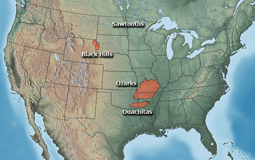
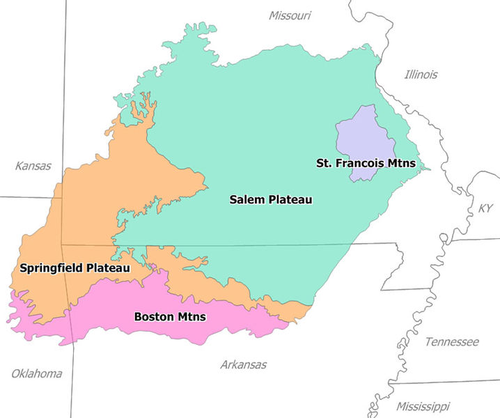
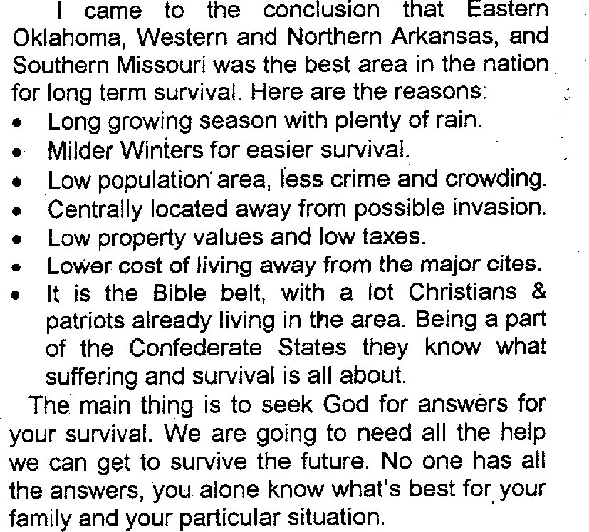
    The Ozark Plateaus
    http://www.nass.usda.gov/Statistics_by_State/Missouri/Publications/Crop_and_Livestock_Reporter/CLR200502.pdf

    THE OZARKS THOUGHT TO BE AN IDEAL “SAFE HAVEN”

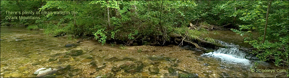
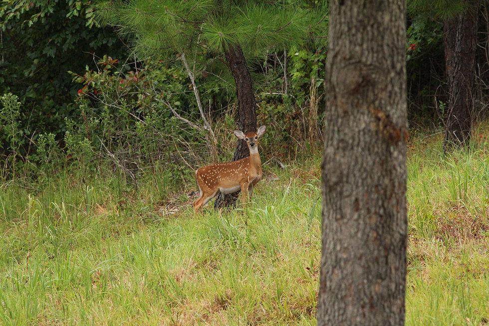
    “The Missouri, Arkansas, Oklahoma Ozark Mountains is the highest rated relocation area between the Appalachians and the Rockies. If you are seeing the need to relocate to a safer area, I would encourage you to consider the Ozarks for the following reasons: hills and mountains, many rivers, abundant forests and wildlife, am ideal elevations, moderate 4 season climate, variety of crop/livestock options, low cost real estate, and a remote location with friendly people.

     Read Joel Skousen’s book

    “Strategic Relocation: North American Guide To Safe Places”


    “Strategic Relocation—Third Edition. The long-awaited, all-new third edition is now in print and available for purchase. In this edition we have updated and expanded our analysis of the threats facing North America and include our opinion of popular overseas tax-havens and expatriate colonies. We have added over 200 pages of in-depth analysis of each US state and the populated regions in Canada. New graphics and color maps show specific threats and recommended relocation areas. Maps include military targets, population densities, satellite images of terrain features, private vs. public land availability and much, much more.”
     

    Hear Joel Skousen tell Alex Jones about the safest places in America, some of the very places shown on my map showing five “safe places”.

    Go into the program exactly 19:10 minutes to hear him show you in his book where these safe areas are, and expound on why the Ozarks are the safest, most ideal of them all.

    His book can be purchased HERE.

    Joel Skousen is a political scientist, by training, specializing in the philosophy of law and Constitutional theory, and is also a designer of high security residences and retreats. He has designed Self-sufficient and High Security homes throughout North America, and has consulted in Central America as well. His latest book in this field is Strategic Relocation–North American Guide to Safe Places, and is active in consulting with persons who need to relocate for security and increased self-sufficiency. He also assists people who need to live near a large city to develop contingency retreat plans involving rural farm or recreation property.

    What would happen to you if a major crisis strikes?

    • What if WalMart and your bank and gas station had to close for a month or even for years?

    • What if an economic crisis threatens your pensions, investments and all of your other sources of income?

    • Do you have an evacuation plan in case there is massive social unrest erupts or a natural disaster?

    • What if the roads/highways to your evacuation are are blocked? Have you researched some alternate routs?

    • What if there is a major terrorist attack on a U.S. city with chemical, biological or nuclear weapons? Are you prepared for that?

    Strategic Relocation: North American Guide to Safe Places is an in-depth analysis you need to plan ahead and select the safest areas for you and your loved ones to live. The 3rd Edition features a complete, newly added section on foreign relocation possibilities plus individual analysis on every state and province in North America. The new color maps show military base locations, city population densities, terrain satellite images, private/public land availability, and much more. This book will help you look ahead for potential threats that most other people fail to see or choose to ignore. It contains a complete discussion of the strategies and relocation contingencies that will help you avoid or mitigate each of the major modern threats, from natural disasters to economic collapse to nuclear war.

    SURVIVAL AND PREPPER BOOKS TO CONSIDER BUYING

    survivalsullivan.com by Dan Sullivan

    http://the-lost-ways.org/ by by Claude Davis

    “Darkest Days – How To Survive An EMP  Attack To The Grid”

    https://www.amazon.com/Darkest-Days-Survive-Attack-Grid/dp/B014B254N0

    “Alive After Crisis by Richard Marshall” 

    http://vkool.com/alive-after-crisis/

    Dirt Cheap Survival Retreat by M. D. Creekmore.  https://www.amazon.com/s/?ie=UTF8&keywords=dirt+cheap+survival+retreat&tag=mh0b-20&index=stripbooks&hvadid=77927956355390&hvqmt=p&hvbmt=bp&hvdev=c&ref=pd_sl_9ljwim9p0e_p

    Several Survival Books by M.D. Creekmoore: https://www.amazon.com/s/?ie=UTF8&keywords=md+creekmore&tag=googhydr20&index=stripbooks&hvadid=174251726353&hvpos=1t3&hvnetw=s&hvrand=12449083156254709768&hvpone=&hvptwo=&hvqmt=e&hvdev=c&hvdvcmdl=&hvlocint=&hvlocphy=9026090&hvtargid=kwd-31428585368&ref=pd_sl_5kznk4hajh_e

    Other books on the same subject matter are also included on all of these sites.

    FLOOD MAPS

    The Ozark mountains are in fact hills and wouldn’t make a noticeable bump on the mountains of Afghanistan, or the Rock Mountains.  The elevation of the Ozark mountains is around 1,000 to 2,000 feet, well above flooding levels, but a four wheeler can drive to the top of most of them.  And being in a southern state we have very little snow, and what we do get will melt the next day.  So from the perspective of being defensible physically, as those great mountain ranges are, that is a little far fetched.  Physically no!  Divinely yes!

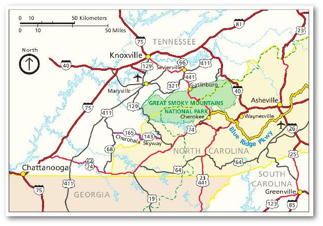
    EDITORS NOTE: There are many maps that show many variations on the theme of flooded areas on the North American continent. Quite frankly I am very skeptical of all of them.  But since this is believed or anticipated as a possibility by so many, it seemed helpful to offer these maps.  

    This map shows the Ozarks as an island surrounded by water.
    The 1998-2012 date is now past, and the shape of the “island” <br/>does not match the shape of Ozark Plateau.

    This map shows a different flooding pattern

    There is said to be more than 1,000 caves in northern Arkansas. Ask if we have a property with a usable cave on it for sale.

    The water level is going down due to overuse in some high population areas, so it is advisable to buy land in low and/or stable population areas where a lot of population growth is not expected.  We would advise you to call a well drilling company in the area you are interested in to see where they have found the best wells.

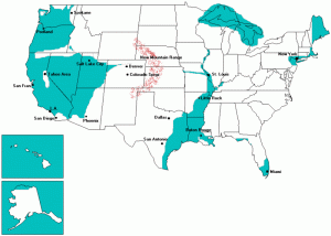
    BUT HERE IS THE MOST BELIEVABLE
    AND LIKELY FLOOD MAP OF ALL

    GO HERE to see the John Moore map in this video on YouTube.  This map and its scenario has verifiable scientific studies behind it.  He has interviewed dozens of US Navy submarine and surface fleet veterans on the subject of rapid global sea level rise, gleaning information from the questions he asks, questions the main stream media is afraid to ask.

    At 11:40 into the video he starts talking about why there are so many retired Navy personnel in the Ozarks. I have heard that some NASA scientists have retired here for the same reason. He talks about the Ozarks again at 8:50 and 45:00 minutes into the video.  The Navy submarine corps says the ocean is rising and the safest place on earth will be the Ozark mountains.  A lot of reports from Oceanographers is used to back up this contention.

    John Moor’s website –www.republicbroadcast.org– links to mine and we have exchanged very brief emails but I have never met him.  As you can imagine, his HQ is in the Ozarks as well as ArkHaven’s.

    SURVIVING THE POLE SHIFT

    In my opinion the likelihood of a pole shift or Planet X happening in the next 10 years or more are small to none.  But since a lot of my readers are not as sure as I am, I am providing this video that purportedly shows the safe places in these states in such an event.  I am showing this particular video because it shows all of the Ozarks as being a safe location.  In all of Chris Thomas’ videos he shows safe places in all the states that have any.  In some states there are no safe places. In several cases the whole state, or a large portion of it will be under water.

    Here are his comments pertaining to this video.

    Safe Locations for Arkansas, Louisiana, Mississippi,

    Alabama, Georgia, Florida, South & North Carolina, Tennessee

    April 10, 2016 by Chris Thomas

    “The plan is to understand the dangers of the coming pole-shift and prepare against them. The run-down to the Pole-shift is also tricky and dangerous in the latter stages. We have to live a double-life meanwhile: maintain our personal, social and business network all the while preparing and keeping an eye on Planet X-caused Earth change events.”  ~April 10, 2016 – Chris Thomas

    “Continuing in my series of Safe Location videos, state-by-state of the USA, this video describes the basic situations for the states of Arkansas, Louisiana, Mississippi, Alabama, Georgia, Florida, South & North Carolina and Tennessee. States of  Louisiana, Mississippi, Alabama and Florida will be essentially be under water after the Pole-Melt, which I think will completed by 2025, so not recommended to try to locate permanent survival areas anywhere in those states. South Carolina and Georgia will mostly flood but have easy access to the highlands of Tennessee, with the slight exception of Georgia’s high lands which will over populate, along with Tennessee in the After-Time, so both states are off the list of good survival states. Tennessee will suffer from overpopulation as many migrants from the lower gulf states will naturally move and try to settle there during the march of the rising sea sea level in the After-Time. North Carolina is a special situation where sociological problems of a disparate community of very different people and lifestyles try to occupy the same mountainous zone of the southern US, therefore I discuss North Carolina in it’s own segment.”  ~ April 10, 2016 – Chris Thomas

    SEE THIS VIDEO:

      https://survivingthepoleshift.com/2016/04/10/safe-locations-for-arkansas-louisiana-mississippi-alabama-georgia-florida-south-north-carolina-tennessee/

    The Green Island of Survival…
    May Possibly, at least for a time, once again, be a Literal Island

    WIKIPEDIA DESCRIPTION OF THE OZARK MOUNTAINS

    The Ozarks, also referred to as the Ozark Mountains, Ozarks Mountain Country, and the Ozark Plateau, is a physiographic and geologic highland region of the central United States; primarily located in Arkansas and Missouri. The Ozarks cover a significant portion of southern Missouri extending as far northeast as the southwestern suburbs of St. Louis. In Arkansas, a large portion is contained within the northwestern and north central region. Much smaller pieces of the Ozarks extend westward into northeastern Oklahoma and extreme southeastern Kansas.

    The Shawnee Hills of southwest Illinois, which lie near the eastern edge of this region, are commonly called the “Illinois Ozarks” but are generally not considered part of the true Ozarks.

    Although referred to as the Ozark Mountains, the region is actually a high and deeply dissected plateau. Geologically, the area is a broad dome around the Saint Francois Mountains. The Ozark Highlands area, covering nearly 47,000 square miles (122,000 km2), is by far the most extensive mountainous region between the Appalachians and the Rocky Mountains. Together, the Ozarks and Ouachita Mountains form an area known as the U.S. Interior Highlands, and are sometimes referred to collectively. For example, the ecoregion called Ozark Mountain Forests includes the Ouachita Mountains, although the Arkansas River Valley and the Ouachitas, both south of the Boston Mountains, are not usually considered part of the Ozarks.

    The Boston Mountains contain the highest elevations of the Ozarks with peaks over 2,500 feet (760 m)s and form the greatest relief of any formation between the Appalachian and Rocky Mountains. The Boston Mountains portion of the Ozarks extends north of the Arkansas River Valley 20 to 35 miles (32 to 56 km) and is approximately 200 miles (320 km)[19] and are bordered by the Springfield and Salem Plateau to the north of the White River. Summits can reach elevations of just over 2,560 feet (780 m) with valleys 500 to 1,550 feet (472 m) deep (150 m to 450 m). Turner Ward Knob is the highest named peak. Located in western Newton County, Arkansas, its elevation is 2,463 feet (751 m). Nearby, five unnamed peaks have elevations at or slightly above 2,560 feet (780 m). Drainage is primarily to the White River, with the exception of the Illinois River. Many Ozark waterways have their headwaters in the uplands of the Boston formation, including the Buffalo, King’s, Mulberry, Little Red and White rivers.[20]

    Topography is mostly gently rolling in the Springfield and Salem Plateaus, where the Saint Francois Mountains are more rugged. The Springfield formation’s surface is primarily Mississippian limestone and chert, where the Salem Plateau is older Ordovician dolostones, limestones, and sandstones. Both are rife with karst topography and form long, flat plains. The formations are separated by steep escarpments that dramatically interrupt the rolling hills. Although much of the Springfield Plateau has been denuded of the surface layers of the Boston Mountains, large remnants of these younger layers are present throughout the southern end of the formation, possibly suggesting a peneplain process. The Springfield Plateau drains through wide, mature streams ultimately feeding the White River.

    (Source: https://pediaview.com/openpedia/Ozarks

    and https://en.wikipedia.org/wiki/Ozarks

    and  http://www.bing.com/knows/search?q=ozarks&mkt=zh-cn)

     THE OZARKS A GREAT PLACE FOR SURVIVAL AGRICULTURE

    The Ozarks are far enough south in the continental USA to allow for two growing seasons and very mild winters.  In Arkansas there are many apple orchards and grape vineyards, green bean and Spinach fields and canneries to process them.  We have already gone on at length about all the rain, all the springs and creeks that provide more that adequate water to grow these crops.

    I advocate an agrarian, off the grid, self sustaining life style that has worked successfully for 6000 years of human history.

     LAND, WITH WATER AND FOOD PRODUCTION ON IT WILL BECOME THE DECIDING FACTOR

    Water may become more valuable than gold some day.  By divine providence (?) 2.5 Billion Gallons of water surge from the earth daily in this Ozark aquifer system. We have a lot of rain and many large lakes and rivers and springs.  We’ve’ got water!

    When WalMart closes, when the gas station closes, and when your bank closes… folk you had better be in a safe place where you can living off-the-grid and be self sufficient enough to make it long term. These are real possibilities we should be preparing for.  Live where you can provide both for your family and those God may send to you.  Think of prepping as adopting an agrarian life style –homesteading– that has worked for 6,000 years rather than as running in fear hoping to survive.

    QUESTIONS? COMMENTS? CONCERNS?
    WRITE TO US!

    Ozarks Sanctuary  |

      Safe Christian Sanctuary